Understanding Auckland water infrastructure constraints and how they impact development projects.Why Auckland Water Infrastructure Constraints Are Increasing
Auckland is growing fast, and with that growth comes pressure on its water and wastewater systems. Watercare, the organisation responsible for managing these services, faces major challenges keeping up with demand. Here’s a quick overview of what’s happening and what it means for you.
Since Auckland’s water services were unified in 2010, the region has seen rapid population growth and urban expansion. The 2016 Auckland Unitary Plan encouraged more intensive development, which has added even more pressure on the existing systems. As a result, some areas now have limited capacity for water and wastewater services, potentially slowing new developments unless upgrades are made.
How to Check Auckland Water Infrastructure Constraints in Your Area
Watercare has a tool to help identify areas with infrastructure constraints. You can access their interactive map to see if your property is in an affected zone. Here’s how:
- Visit Watercare’s mapping tool.
- Agree to the terms and conditions.
- Use the search bar to find your property and check its status.
The map shows:
- Areas with wastewater constraints.
- Areas with water supply issues.
- Zones with both types of limitations.
For the most accurate results, perform a detailed analysis of your specific site.
What Auckland Water Infrastructure Constraints Mean for Development
If your property falls within a constrained area, it doesn’t necessarily mean you can’t develop. Each project is reviewed based on factors like location, demand, and development scale. Some developments may proceed if aligned with planned upgrades or alternative solutions.
Key options include:
- Building up to three dwellings in certain residential zones under permitted activity rules.
- Applying for conditional consents that match the timing of infrastructure improvements.
- Exploring subdivision options around existing developments.
Watercare’s Plans for the Future
Watercare is addressing these challenges through large-scale infrastructure projects, some of which are scheduled for completion between 2025 and 2040. These projects include major upgrades to treatment plants and network expansions to support Auckland’s growth.
Need Expert Advice on Auckland Water Infrastructure Constraints?
Navigating these constraints can be tricky. If you’re planning to develop in Auckland, doing a through due diligence and early consultation with experts can save time and money. Our team at RPC Land Surveyors can assess your project’s viability and provide tailored advice.
Click here to ask us more about how we can support your best work.
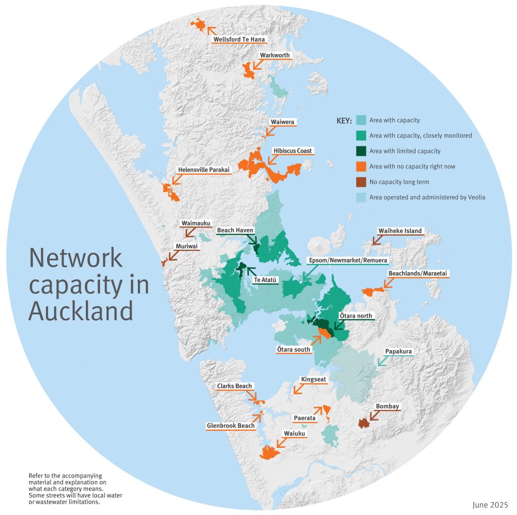
Network Capacity in Auckland | Image Source | Watercare website (Auckland), click here to learn more.
Planning Ahead for Auckland Development Success
Understanding and navigating Auckland’s water infrastructure constraints is essential for any development project. Early assessment, careful planning, and consultation with experts can save time, reduce costs, and increase the likelihood of project approval. Developers who proactively consider water and wastewater limitations, align their projects with planned infrastructure upgrades, and use tools like Watercare’s interactive map are better positioned to succeed in Auckland’s competitive development environment.
RPC Land Surveyors provide professional advice on site viability, infrastructure constraints, and compliance requirements, helping developers make informed decisions. Whether you are planning a residential subdivision, multi-dwelling project, or commercial development, our team can guide you through the complexities of Auckland’s water and wastewater systems, ensuring your project aligns with both current capacity and future growth plans.
Contact RPC Land Surveyors to discuss your project and get expert guidance on navigating Auckland’s water infrastructure constraints.