Easements explained

Easements come in many shapes and forms. Generally it gives one person the right to use another person’s land for a particular purpose, and are recorded on the properties certificate of title. There are private easements between individuals for services and access, and ‘Easements in Gross’ which are in favour or councils or corporations.

A common easement is a ‘Right of Way’ which allows a person to travel across another person’s land to get access to there property. The Right of Way area must be kept clear and you can’t block that persons use of the Right of Way by parking vehicles on the Area of land defined as the Right of way area.

The easement area is usually defined on a survey plan, but some older easements are shown on a diagram in the certificate of title. There is an easement document recorded on the certificate of title, and prepared by a solicitor that records the specific details of the easement, and obligations.

Easements can be created, changed, and surrendered. Generally easements are created at the time of subdivision of a property, but can be created at any time.  It pays to talk to your surveyor and solicitor if easements effect your property and what they mean for each party, or you require an easement to be created.

The Mysteries of a Cross-lease explained

What is a Cross-lease?

A cross-lease is a form of property ownership arrangement, primarily found in New Zealand. In a cross-lease, multiple parties own a share of the land collectively, and each party has a leasehold interest in a specific portion of the land. Typically, this type of ownership is associated with residential properties.

Here’s how it generally works:

1.      Land Ownership: The land is owned jointly by all the parties involved in the cross-lease. Each party holds a share in the land.

2.      Leasehold Interests: Each property owner also holds a lease on their specific portion of the land. This lease outlines the rights and responsibilities of the individual property owner concerning their dwelling and the land they occupy.

3.      Dwellings: Each party usually has  a separate dwelling (house, apartment, garage etc.) on their leased portion of the land.

4.      Mutal Agreement: As co-owners of the land, residents must each reach a mutual agreement on issues that affect the entire property, such as maintenance, renovations or changes to common areas.

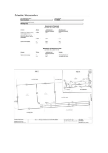
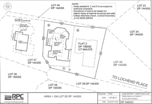
Typical Cross-lease Land Transfer Survey Plan

While cross-leases were popular in the past, they can sometimes lead to complications. Issues may arise when changes are made to the property without the consent of other parties, or when disagreements arise over the use and maintenance of common areas. In recent years, freehold ownership has become more common and is often considered a simpler and more straightforward form of property ownership compared to cross-leases.


What is a defective Cross-lease Title?

A defective cross-lease title refers to a situation where there are errors, omissions, or issues with the legal documentation associated with a cross-lease property. The defects could be related to the original cross-lease agreement, the lease documents, or the plans associated with the property. These defects can create legal and practical problems for property owners

Common issues with defective cross-lease titles may include:

1.      Incorrect Boundaries: Errors in defining the boundaries of each owners share in the land or dwelling can lead to disputes and complications.

2.      Missing or Inaccurate Plans: Incomplete or inaccurate plans, floor plans or other associated documentation can create confusion and disputes among cross-lease agreement, lease documents and other legal documents, it can lead to legal uncertainties and disputes.

3.      Lack of Consistency: If there are inconsistencies between the cross-lease agreement, lease documents and other legal documents, it can lead to legal uncertainties and disputes.

4.      Unapproved alterations: If one of the property owners has made alterations to their dwelling without obtaining proper consent from the other parties, it can lead to issues when selling or transferring the property.

5.      Failure to Register Changes: Changes made to the cross-lease agreement or other relevant documents that are not properly registered with the appropriate authorities can result in a defective title.

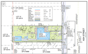
Original Cross-lease flats Plan

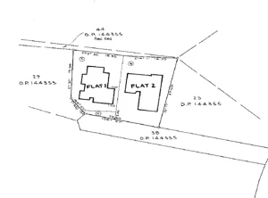
Cross-lease flats Plan Update Following Extensions

Dealing with a defective cross-lease title will require a Licensed Cadastral Surveyor to obtain a resource consent & update the Flats Plan and legal assistance to rectify the issues. It’s crucial for property owners to address these defects promptly, especially if they plan to sell or transfer the property, as defective titles can complicate the transaction process. Consulting with RPC Land Surveyors your professional Licensed Cadastral Surveyors in the first instance is advisable to navigate the complexities and find appropriate solutions. If you have defective title and need it corrected please get in touch with your local RPC Land Surveyors office, we’ll be more than happy to assist.

By 

Meet our new Planner

Sam has a total of 15 years experience in the field of planning ranging from processing resource consents, undertaking policy drafting work, infrastructure planning and reserves management planning within local government. Sam began her career with New Plymouth District Council in 2007. In 2018 she worked for Isovist, New Zealand’s leading e-plan provider as a Delivery Manager managing Council’s e-plans across New Zealand and later in 2021 worked for Far North District Council in project managing the delivery of the Far North Proposed District Plan.

A few words from Sam;

I have a passion for open space through the work I did for local government. I worked on some exciting 30 year projects to connect New Plymouth’s ‘Mountain to Sea’ and ‘Pouakai Crossing’ projects.

 I love working with people and collaborating with a variety of experts to come up with the best solution to a problem. I love a challenge!

 On a personal note, Sam adds:

Home is where the heart is. Mount Maunganui! I certainly feel at home here being close to Mauao and the beach. I was born in the UK but moved to New Zealand as a youngster. Being close to the beach soothes my soul!

I have a passion for yoga and meditation and love being in the water down at the local beach! I am also a qualified Kundalini Yoga, Mantra and Meditation teacher and love sharing this incredible technology with like-minded souls to better other lives.

Qualifications:

Bachelor of Resource and Environmental Planning

Professional Affiliations:

Member of New Zealand Planning Institute

Environmental Benefit Lots (EBL)

Environmental benefit lots are a form of subdivision that allows landowners to create new lots in exchange for protecting and enhancing areas of significant natural value.

Today we were undertaking the physical survey of a proposed environmental benefit lot in the Waipa District. The Waikato District Plan provides criteria and standards for environmental benefit lots in rural zones, such as the size, location, and shape of the lots, as well as the type, extent, and quality of the environmental features to be protected. The process of surveying and creating environmental benefit lots involves applying for a resource consent from the Waikato District Council, engaging a qualified surveyor to prepare a scheme plan and a survey plan, and registering the covenant areas with Land Information New Zealand. The surveying and creation of environmental benefit lots can contribute to the preservation and restoration of biodiversity, landscape, and cultural values in the Waikato district. It was fantastic to see the increased wildlife now inhabiting the area and having a positive effect on the natural landscape. Our team has extensive experience in creating and securing environmental benefit lots in the Waipa region. We can help you with the identification, procurement of funding, establishment, and legalisation of these lots, which are valuable for conservation and development purposes.

Environmental benefit lots are a form of subdivision that allows landowners to create new lots in exchange for protecting and enhancing areas of significant natural value. Today we were undertaking the physical survey of a proposed environmental benefit lot in the Waipa District. The Waikato District Plan provides criteria and standards for environmental benefit lots in rural zones, such as the size, location, and shape of the lots, as well as the type, extent, and quality of the environmental features to be protected. The process of surveying and creating environmental benefit lots involves applying for a resource consent from the Waikato District Council, engaging a qualified surveyor to prepare a scheme plan and a survey plan, and registering the covenant areas with Land Information New Zealand. The surveying and creation of environmental benefit lots can contribute to the preservation and restoration of biodiversity, landscape, and cultural values in the Waikato district. It was fantastic to see the increased wildlife now inhabiting the area and having a positive effect on the natural landscape. Our team has extensive experience in creating and securing environmental benefit lots in the Waipa region. We can help you with the identification, procurement of funding, establishment, and legalisation of these lots, which are valuable for conservation and development purposes

Celebrating Christmas with a SPLASH

This Christmas, we’re swapping the traditional sleigh for a black water tube at Waitomo Caves. Embarking on a thrilling underground journey, both RPC and Nicklin CE offices explored the magical glowworm-lit caverns to celebrate the end of 2023.

Who needs snow when you have the enchanting glow of thousands of tiny lights surrounding you?  From the depths of the caves to the spirit of the season, we’re making memories that will last a lifetime.

Wishing you all a Merry Christmas filled with adventure, joy and the warmth of loved ones!

Landslide Monitoring

Our dedicated survey team is diligently monitoring the houses atop the recently shifted terrain following the landslide. Armed with the precision of a Total Station, we’re conducting x, y, z measurements – a crucial aspect of our detailed monitoring surveys. These precise measurements are not just data points; they are key to assessing the structural integrity of each existing lot above the slip area.

Our focus is unwavering as we work to provide residents with accurate insights into any changes. The Total Station accompanied with post processing technology in the office enables us to capture the slightest shifts, ensuring that safety remains paramount.

These monitoring surveys aren’t just about measurements; they’re a commitment to the well-being of those living on the edge of change. We’ll continue utilising the latest technology to keep everyone informed and secure in the wake of this natural event.

By 

The Landing Business Park

The Landing is a new business park at Auckland Airport catering to logistics, technology and light industrial sectors. It encompasses 175 hectares and is home to some of the world’s largest logistics companies.

For the past 8 years RPC has been assisting contractors in providing as-builts of the new drainage assets at this new business park.  An As-Built Plan typically shows the final position and level of new infrastructure assets. They are usually required by Councils to ensure the assets meet engineering requirements and that this information can be loaded into GIS systems for an up-to-date record.

We also inspect the condition of the new drainage and alert the client/drainlayer of any damage that has occurred during construction.

Once a plan has been accepted, payment received and inspections completed, a completion certificate is issued and Council will take over ownership of any Public assets.

The Importance of a Site Survey and Site Plan

At the start of any subdivision development the initial critical survey is for a site plan of the property. This provides you with all the base information required for the future development.

The site plan will pick up the site and boundary ground levels, any existing building locations in relation to the legal boundaries, manholes and above ground services, street furniture including vehicle crossings, kerb, footpath and any power poles, and stormwater cesspits.

The plan forms the basis of the scheme plan for subdivision and can also be used for any engineering design required. The plan can also be used by an architect for the future house design.

So the importance of a good clear, detailed site survey should not be underestimated.

House Set Out in the Kaimai Ranges

Rodney recently had the pleasure of setting out a house situated in the lower Kaimai Ranges with gorgeous panoramic views over the Western Bay Area.

Building a house is an intricate process that begins long before the first brick is laid, or the foundation is poured. A land surveyor’s role in setting out a house cannot be overstated. Their meticulous work in mapping the property, identifying boundaries, and transferring architectural plans to the site is essential for a successful construction project. By ensuring precision and accuracy, land surveyors play a fundamental role in creating not just houses but homes that stand the test of time. Their expertise contributes to the integrity, safety, and legal compliance of every structure, making them an indispensable part of the construction process.

Marking the Journey & School of Surveying’s 60th Anniversary

Marking the Journey” could not have been a better theme for this year’s conference as it was the School of Surveying’s 60th anniversary. The theme also aligned with the republished autobiography of Archie Bogle in the Part I of the three-part book, ‘The Measure of the Man’, allowing us to look back in time to allow us to reflect and appreciate the Journey that has been. “Walking backwards into the future”, a phrase thrown around at the conference, reminding us, that to best prepare ourselves for the future we need to look into the past.

The three-day conference was jam-packed with informative and educating presentations from modernising Landonline, challenges in the City Rail Link project, challenges in large scaled brownfield development from the Piritahi alliance, to a panel discussion on the cadastral system moving to NZTM 2000 and many more interesting presentations.

Upon arriving in Dunedin on the first day, I attended an afternoon session on survey capture in Landonline and in a group we worked through a challenging boundary definition.

If there was a cadastral job to bring out all the cadastral tools out of the toolbox, it was this example. Uplifting the limitations of a parcel that is limited as to parcels, intersections of bearings, half angle calculations, occupation age investigation, questions of adverse possession and questioning what the original intention was of the surveyor, were all required as a minimum to get started.

A job of this complexity required no stone to be left unturned. As a surveyor expecting to sit the professional examination interviews in April 2024, these are the kinds of presentations and group discussions which I can benefit from.

Overall, it was an electric couple of days in the lecture theatres also in the link where it was great to meet former classmates, former lecturers and friends.
The three-day conference was a blast!